CLIENT
Hauts-de-France Region / Géo2France
SCOPE CONCERNED
Territory of the Hauts-de-France region, France
TIMELINE
Since 2018
To meet its needs for the collaborative collection of geographic data, Géo2France initiated the design of the GéoContrib module and contributed to defining its functional specifications and its ongoing evolution. The solution was therefore designed to meet the operational needs of local stakeholders for collecting, updating, and sharing geolocated data.
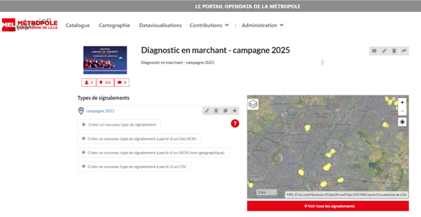
GéoContrib enables the collaborative creation and maintenance of geolocated databases. Users can create contributions directly on a map, enter the associated information, and discuss contributions.
The solution makes it possible to define the type of geometry to collect (point, line, or polygon), the data model and form fields, the available basemaps, as well as access and contribution rights. It also includes commenting and moderation features to facilitate exchanges between contributors and managers.
The development of GéoContrib, based on the specifications and needs expressed by Géo2France, led to the emergence of a new OneGeo Suite module, now offered as a tool for contributing to and collaboratively collecting geographic data.
GéoContrib thus extends the platform’s uses beyond data viewing and publishing, by enabling local stakeholders to participate easily and directly in data production, enrichment, and updating.
Challenges
- Facilitate the collection and updating of territorial data directly by field stakeholders.
- Pool data production among Géo2France’s various partners.
- Improve data quality and freshness through contributions made as close to the field as possible.
- Facilitate the monitoring and moderation of contributions thanks to collaborative features.
- Adapt collection workflows to the needs of each project thanks to configurable forms, data models, basemaps, and access rights.
- Promote the collaborative production of geographic data and its integration into Géo2France’s data ecosystem.
Assignments

Support for Géo2France in defining needs and the functional specifications for the contribution solution
Design and development of GéoContrib based on the specifications defined with Géo2France
Provisioning and deployment of the solution within the Géo2France ecosystem
Configuration of data models, forms, basemaps, and access rights
Maintenance, enhancements, and user support
Solutions
A geolocated contribution solution: collaborative creation and maintenance of databases directly from a map-based interface
Configurable data-entry forms: definition of fields and the data model tailored to each collection project
Collaborative tools: comments, exchanges between contributors, and contribution moderation
Fine-grained rights management: definition of users authorized to view, contribute to, or moderate the data
A solution integrated into OneGeo Suite, able to operate standalone or be connected to other solutions: GéoContrib complements publishing, cataloguing, mapping, and data enhancement features by adding a component dedicated to collaborative data production
An open, interoperable architecture: the ability to integrate produced data into the GIS ecosystem and existing data platforms