CLIENT
European Metropolis of Lille (MEL)
SCOPE CONCERNED
Territory of the European Metropolis of Lille, France
TIMELINE
Since 2024
The European Metropolis of Lille has a geographic data infrastructure and a data portal that centralize, publish, share, and leverage the data produced by the Metropolis, the municipalities, and its partners.
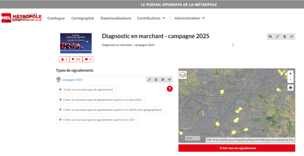
In this context, in 2024 MEL adopted GéoContrib, a module dedicated to the collection and collaborative creation of geolocated data. The solution enables users to create data using input forms, including from mobile devices, and to set up standardized and harmonized data-collection workflows.
The European Metropolis of Lille has played a driving role in the evolution of GéoContrib by expressing new functional needs and thereby contributing to the solution’s development. This co-development approach has made it possible to develop and enhance a tool that meets operational needs for collecting, qualifying, and updating geographic data.
GéoContrib is now integrated into the existing ecosystem and is a module dedicated to the collaborative creation and qualification of geographic databases. MEL continues to contribute to its evolution; in particular, it contributed to GéoContrib version 6.6.
Challenges
- Make it easier for staff, partners, and field stakeholders to create and update geographic data directly.
- Standardize and harmonize data-collection workflows to improve the quality and reliability of the data produced by 95 municipalities.
- Promote collaboration between MEL departments, municipalities, and local partners.
- Reduce the time between collecting information in the field and integrating it into the data infrastructure.
- Maintain a history of monitoring campaigns to ensure traceability of actions carried out, results obtained, and their evolution over time.
- Enable the collaborative creation and qualification of geographic databases through reporting, commenting, and moderation mechanisms.
- Evolve the solution based on users’ needs and feedback, following a co-development and continuous innovation approach.
- A co-innovation approach: MEL’s needs, uses, and feedback directly contribute to the product’s evolution and to the enrichment of OneGeo Suite for the entire community.
Missions

Support for the European Metropolis of Lille in defining needs and the solution’s functional specifications
Design and development of new features in GéoContrib based on the needs expressed by MEL
Deployment and integration of GéoContrib within MEL’s geographic data infrastructure (geOrchestra)
Corrective and evolutionary maintenance of the solution
Incorporation of MEL’s feedback into the roadmap and the enhancement of GéoContrib and OneGeo Suite
Support and training
Solutions
A geolocated reporting solution: collaborative creation and population of databases directly from a map interface
Configurable input forms: definition of fields and the data model tailored to each data-collection project
Collaborative tools: comments, exchanges between contributors, and moderation of contributions
Granular permissions management: definition of users authorized to view, contribute, or moderate data
A solution integrated into OneGeo Suite, which can operate standalone or be connected to other solutions: GéoContrib complements publishing, cataloging, mapping, and data-leveraging capabilities by providing a component dedicated to collaborative data production
An open, interoperable architecture: the ability to integrate the data produced into the GIS ecosystem and existing data platforms